The Upper Mississippi River Basin is a vital and expansive hydrological region in the United States, covering parts of Minnesota, Wisconsin, Iowa, Illinois, and Missouri. Here's an overview:
Geography
Area: The basin spans approximately 189,000 square miles.
Headwaters: It begins at Lake Itasca in Minnesota and extends to the confluence with the Ohio River at Cairo, Illinois.
Landscape: The northern part of the basin is characterized by forests and lakes, while the southern part features highly productive agricultural land.
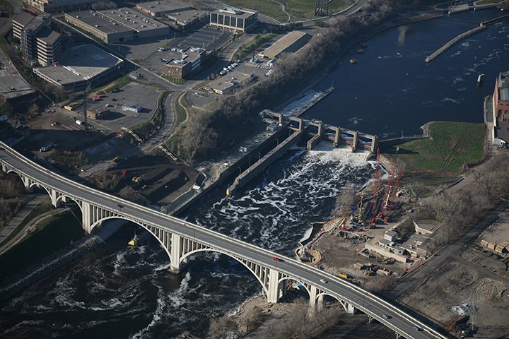
Lower St. Anthony Falls Lock & Dam, Photo Courtesy of US Army Corps of Engineers.
Key Features
Locks and Dams: There are 29 locks and dams on the Mississippi River south of Minneapolis, which regulate water levels and facilitate navigation.
Tributaries: Major tributaries include the Minnesota, St. Croix, Wisconsin, and Illinois Rivers.
Ecosystems: The basin supports diverse ecosystems, including wetlands, floodplain forests, and backwater lakes.
Uses
Navigation: The river is a crucial transportation route, especially for agricultural products like corn and soybeans.
Recreation: Popular activities include boating, fishing, hunting, and swimming. The Upper Mississippi River National Wildlife Refuge spans over 250 miles and covers parts of four states.
Water Supply: The basin provides water for millions of people and supports various industrial and agricultural activities.
Flood Control: The region has extensive flood control measures, including levees and floodplain management strategies.
Challenges
Environmental Impact: Agricultural runoff contributes to sedimentation and nutrient pollution, affecting water quality and contributing to hypoxia in the Gulf of Mexico.
Infrastructure: Many of the locks and dams are aging and require maintenance and upgrades.
The Upper Mississippi River Basin is a dynamic and essential part of the U.S. landscape, balancing ecological health with human use and economic activity.